Have you ever wondered how many feet above sea level your location is? Whether you are planning a hike, checking flood risks, traveling to the mountains, or simply curious about your surroundings, elevation can tell you a lot about where you live or travel.
Elevation above sea level affects weather, air pressure, climate, health, and even cooking. Modern technology now makes it easy to find your exact elevation using smartphones, GPS devices, and online tools.
In this guide, you will learn what elevation means, why it matters, how to check it accurately, and how sea level measurements work in everyday life.
What Does “Above Sea Level” Mean?
“Above sea level” refers to the height of a location compared to the average level of the ocean’s surface, also called mean sea level.
For example:
- If a city is 500 feet above sea level, it means the land is 500 feet higher than the ocean’s average surface.
- A mountain may sit thousands of feet above sea level.
- Some areas are actually below sea level.
Elevation is usually measured in:
- Feet (commonly used in the United States)
- Meters (used in most other countries)
People often confuse elevation and altitude, but they are slightly different.
| Term | Meaning |
|---|---|
| Elevation | Height of land above sea level |
| Altitude | Height of an object in the air |
| Depth | Distance below sea level |
Understanding this difference helps when reading maps, GPS devices, or weather information.
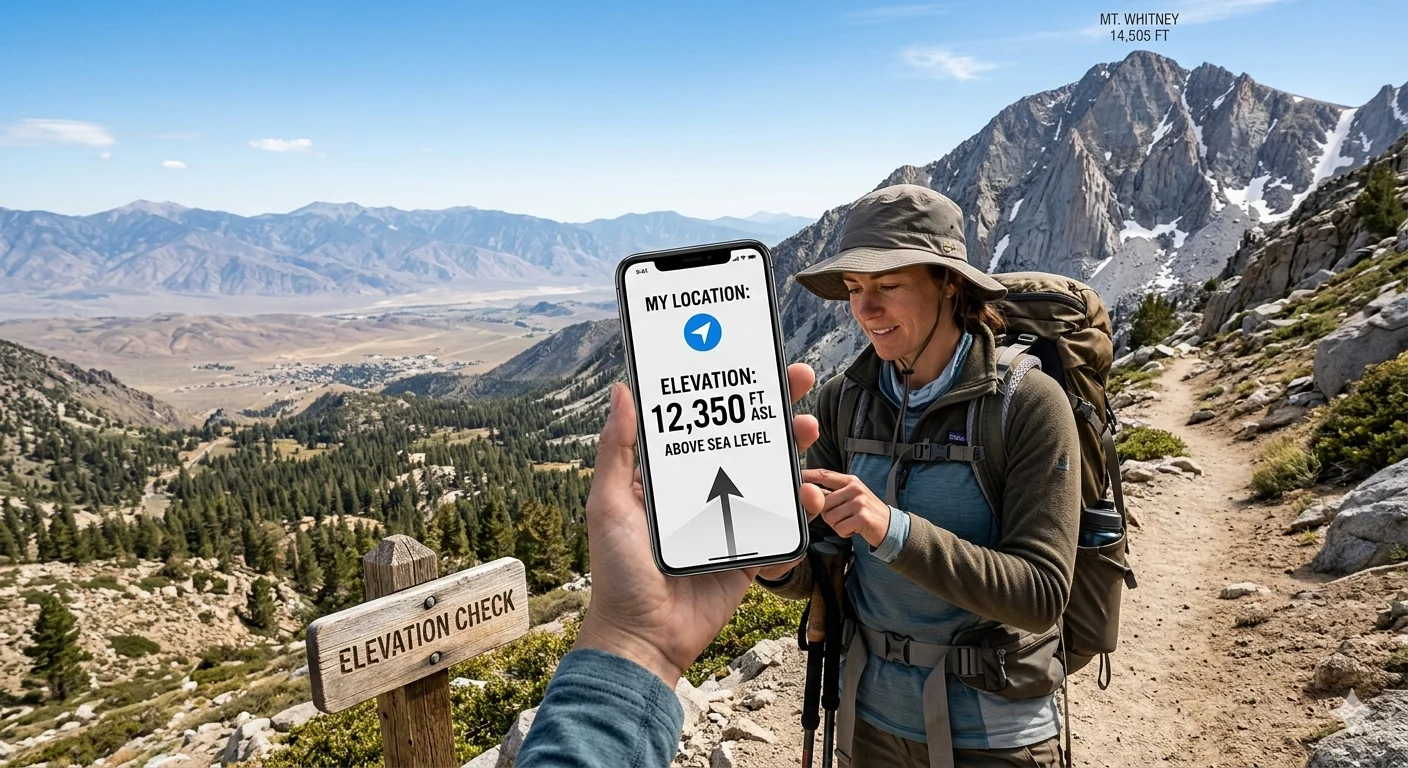
How to Find How Many Feet Above Sea Level Your Location Is
Today, checking elevation is quick and simple. You do not need professional equipment in most cases.
Using Your Smartphone
Most modern smartphones include GPS technology that can estimate your elevation.
On Android Devices
You can:
- Open Google Maps
- Tap your blue location dot
- Use an elevation app for detailed readings
Popular apps include:
- My Elevation
- GPS Altimeter
- Altimeter GPS
On iPhone
The Compass app may show elevation data:
- Open the Compass app
- Allow location access
- View the elevation reading
The accuracy depends on GPS signal strength and your surroundings.
Using Google Maps
Google Maps terrain mode can help estimate elevation.
Steps:
- Open Google Maps
- Click Layers
- Select Terrain
- Zoom into your location
Contour lines and terrain shading help visualize elevation changes.
Using Online Elevation Tools
Many websites instantly calculate your elevation.
Popular choices include:
- Elevation Finder
- GPS Visualizer
- FreeMapTools
- Topographic-map.com
These tools use GPS coordinates and terrain databases to estimate height above sea level.
Using GPS Devices
Dedicated GPS units are commonly used by:
- Hikers
- Pilots
- Engineers
- Surveyors
Professional GPS systems are usually more accurate than smartphones because they connect more reliably to satellites.
Why Elevation Matters
Many people think elevation only matters for mountain climbing, but it affects daily life in several important ways.
Weather and Climate
Higher elevations usually have:
- Cooler temperatures
- Lower air pressure
- More snowfall
- Stronger sunlight exposure
Temperature typically drops around 3.5°F for every 1,000 feet gained in elevation.
This is why mountain towns are often much cooler than nearby lowland cities.
Health and Breathing
At higher elevations, oxygen levels decrease.
Some people experience altitude sickness, especially above 8,000 feet.
Common symptoms include:
- Headaches
- Fatigue
- Dizziness
- Shortness of breath
People living in high-altitude areas often adapt over time, but visitors may need time to adjust.
Flood Risk
Knowing how many feet above sea level your location is can help determine flood danger.
Low-elevation areas near oceans or rivers are more vulnerable to:
- Storm surges
- Coastal flooding
- Rising sea levels
Homebuyers often check elevation before purchasing property in flood-prone regions.
Hiking and Outdoor Activities
Hikers and campers monitor elevation because it affects:
- Trail difficulty
- Energy levels
- Weather conditions
- Oxygen availability
A steep elevation gain can make a short hike much more challenging.
Average Elevation Levels Around the World
Elevation varies dramatically across different locations.
| Location | Approximate Elevation |
|---|---|
| Amsterdam | Below sea level |
| New York City | 33 feet |
| London | 36 feet |
| Denver | 5,280 feet |
| Mexico City | 7,350 feet |
| Kathmandu | 4,593 feet |
Denver is known as the “Mile High City” because it sits approximately one mile above sea level.
Meanwhile, some areas in the Netherlands are below sea level and protected by advanced flood-control systems.
How Elevation Is Measured
Modern technology measures elevation using several advanced methods.
GPS Technology
GPS devices communicate with satellites to determine:
- Latitude
- Longitude
- Elevation
Your device calculates your location based on signals from multiple satellites.
However, elevation measurements can sometimes vary slightly because vertical positioning is harder to measure accurately than horizontal position.
Topographic Surveys
Surveyors use professional tools to create highly accurate land measurements.
These surveys help with:
- Construction
- Engineering
- Road development
- Land planning
Topographic maps use contour lines to represent elevation changes.
Satellite and Radar Mapping
Modern terrain maps also use:
- Satellite imaging
- Laser scanning
- Radar technology
These systems create digital elevation models used for mapping and scientific research.
Feet vs Meters Above Sea Level
Different countries use different elevation units.
| Feet | Meters |
|---|---|
| 100 ft | 30.48 m |
| 500 ft | 152.4 m |
| 1,000 ft | 304.8 m |
| 5,000 ft | 1,524 m |
| 10,000 ft | 3,048 m |
Quick conversions:
- Feet to meters → multiply by 0.3048
- Meters to feet → multiply by 3.281
The United States commonly uses feet, while most countries use meters.
Common Mistakes When Checking Elevation
People often misunderstand or misread elevation data.
GPS Signal Problems
GPS accuracy can decrease because of:
- Tall buildings
- Dense forests
- Bad weather
- Weak signals
Your elevation reading may fluctuate slightly even when standing still.
Confusing Elevation With Altitude
Remember:
- Elevation refers to land height
- Altitude refers to height in the air
This distinction is especially important in aviation.
Indoor Readings
Indoor measurements are usually less accurate because walls and roofs interfere with satellite signals.
For better accuracy:
- Go outdoors
- Wait for stronger GPS connection
- Compare multiple tools
Best Tools to Check Elevation
Several apps and tools make it easy to check how many feet above sea level your location is.
| Tool | Best For |
|---|---|
| Google Maps | General users |
| My Elevation App | Quick mobile checks |
| GPS Devices | Hiking and navigation |
| Elevation Finder | Online elevation lookup |
| AllTrails | Outdoor adventures |
Outdoor apps often include:
- Trail elevation profiles
- Terrain maps
- Distance tracking
- Route planning
Interesting Facts About Elevation and Sea Level
Elevation science includes many fascinating facts.
Highest Point Above Sea Level
Mount Everest is the highest mountain above sea level at approximately 29,032 feet.
Lowest Land Elevation
The shoreline of the Dead Sea sits about 1,410 feet below sea level.
Sea Level Is Not Perfectly Flat
Sea level changes due to:
- Ocean currents
- Gravity
- Earth’s rotation
- Climate patterns
Scientists therefore use “mean sea level” instead of a perfectly flat ocean reference.
Elevation Can Affect Cooking
At higher elevations:
- Water boils faster
- Cooking temperatures change
- Baking recipes may need adjustment
This is why mountain cooking often requires different preparation methods.
Frequently Asked Questions
How can I find how many feet above sea level my location is?
You can use smartphone apps, GPS devices, online elevation finders, or terrain maps to check your elevation instantly.
Is smartphone elevation accurate?
Smartphones are usually reasonably accurate, but readings can vary depending on GPS quality and environmental conditions.
Why does elevation matter?
Elevation affects weather, health, hiking difficulty, flood risk, and climate conditions.
What is considered high elevation?
Areas above 5,000 feet are generally considered high elevation, while altitude sickness often begins around 8,000 feet.
Can locations be below sea level?
Yes. Some regions around the world sit below sea level, including parts of the Netherlands and areas near the Dead Sea.
Conclusion
Knowing how many feet above sea level your location is can help you better understand weather, climate, travel conditions, and environmental risks. Elevation also plays an important role in hiking, health, construction, and property planning.
Thanks to smartphones, GPS systems, and online tools, checking your elevation is now easier than ever. Whether you live near the coast or in the mountains, understanding your height above sea level provides valuable insight into your environment and surroundings.